Skip to main content
NAVIGATION
Contact
Help
Advanced Search
Search Term
SEARCH
Account Menu
HOME
COLLECTIONS
INSTITUTIONAL REPOSITORY
ARCHIVAL COLLECTIONS
THESES AND DISSERTATIONS
CONTRIBUTE
JOURNALS
ABOUT
CONTACT
FIND WHAT YOU ARE LOOKING FOR
Search Term
SEARCH
3
Results for:
All
Collections
Objects
Results Per Page
10
20
50
RELEVANCY
DATE
TITLE
Atlanta University Center Robert W. Woodruff Library
(x)
1920-1929
(x)
cartographic
(x)
Search results
For:
Institution = Atlanta University Center Robert W. Woodruff Library
Decade = 1920-1929
Document Type = cartographic
Neighborhood Union Collection
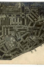
Atlanta Map, Zone D, circa 1925
Date Created
1920/1925
Description
Zone D map of Atlanta, with border streets of Ashby, Greensferry, Lee, and the Southern Railroad.
Subject
African American neighborhoods, African Americans--Georgia--Atlanta, African Americans--Housing
Collection
Neighborhood Union Collection
Neighborhood Union Collection
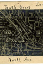
Atlanta Map, Zone A, circa 1925
Date Created
1920/1925
Description
Zone A map of Atlanta, with border streets of Tenth, State, Ashby, and North.
Subject
African American neighborhoods, African Americans--Georgia--Atlanta, African Americans--Housing
Collection
Neighborhood Union Collection
Neighborhood Union Collection
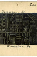
Atlanta Map, Zone C, circa 1925
Date Created
1920/1925
Description
Zone C map of Atlanta, with border streets of Simpson, Southern, West Hunter, and Ashby.
Subject
African American neighborhoods, African Americans--Georgia--Atlanta, African Americans--Housing
Collection
Neighborhood Union Collection